Home | Fall Foliage Tour
fall foliage tour
Honestly, anywhere you go in Maine’s Lakes and Mountains in Late September and October will deliver a colorful experience filled with reds, golds, and russets. The first color to pop is often the bright reds of the swamp maples. Golden rod and sumac add to the palette. But Peak Foliage Week is typically the second week in October in Western Maine, according to MaineFoliage.com. Colors may peak a little sooner in the far northern areas of the region around Eustis and Coburn Gore for adventurous visitors.
Get the most out of your Fall Adventure
Whether a day trip or a long weekend — we created a Fall Foliage Tour that combines portions of each of the four Scenic Byways in the region plus some suggested stops along the way to eat, sample local brews, shopping, get outdoors, and cozy up for the night. You can easily drive all or just a portion of it and still take in some of Maine’s best Autumn color displays.
The Map below shows the loop route and various scenic stops, towns where visitors can enjoy the night or a meal. There are covered bridges and waterfalls to be seen. Quirky attractions or museums to fill a little time. Plus, local shops and galleries to find that perfect momento of the trip. Hover over any of the map icons below for tips and suggestions.
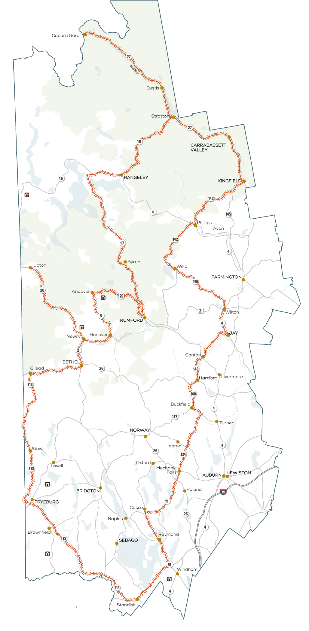
You can start at any point on this loop and then travel in either direction, but if you are coming from the south, we suggest starting in Standish and traveling clockwise.
The northern portion of the region will see peak colors near the first of October, while the central and southern portions will turn in succession through the third week of the month.
Find top-notch leaf peeping on the Grafton Notch Scenic Byway. An out-and-back side route from the Fall Foliage Tour begins in Newry and ends in Upton, spanning 21 miles with views of waterfalls, the Mahoosuc Mountain Range, Grafton Notch State Park, and Lake Umbagog.
The Pequawket Trail Scenic Byway snakes along the Saco River in the shadow of the White Mountains and connects the towns of Standish, Fryeburg, and Evans Notch as it weaves in and out of New Hampshire.
This tour runs up the western side of the Rangeley Lakes National Scenic Byway. This portion of the drive passes high mountain lookouts, sparkling blue lakes, and dense, blazing deciduous forests.
Join up with the Maine High Peaks Scenic Byway in the town of Stratton, where you have a choice. Head north for the grand tour along Rt. 27 up to the Canadian Border. Or head south through Carrabassett Valley to Kingfield.
If you arrive early in the foliage season this will deliver the most color. Mid way through October it will generally be past peak.
Also known as the Sunday River Bridge, The Artist’s Bridge is Maine’s most photographed and painted covered bridge. This is a quick stop is right along the tour's route.
The Parsonsfield-Porter Bridge was built over the Ossipee River along Kezar Mountain Rd. in 1859. This pleasant side trip along Rt. 160 winds through Maine's western foothills.
Hemlock Bridge, a 109-foot Paddleford truss bridge strengthened with laminated wood arches passes over the Saco River.
The Bennet Bridge, a 93-foot-long bridge, spans the Magalloway River near Wilson’s Mills and Lincoln Plantation. This would require a side trip along more remote roads, but for Covered Bridge collectors it is worth the adventure.
The 70-foot Lovejoy Bridge, built in 1868, spans the Ellis River. Constructed of Paddleford trusses, it is Maine’s shortest covered bridge. This bridge is also a quick stop off the route.
The Oquossoc Log Church is a historic non-denominational church in the Oquossoc village of Rangeley. It is a unique structure whose walls and major interior fixtures are built from spruce logs.
The Height of Land scenic overlook offers breathtaking unspoiled vistas along the Rangeley Lakes Scenic Byway. This spot is considered one of the most impressive overlooks in New England, with broad views of the Richardson Lakes, the White Mountains, and Mooselookmeguntic.
As you pass through Rumford, watch for Paul Bunyan and Babe the Blue Ox welcoming visitors to the town, providing a great “selfie” opportunity to remember your time by. Stop into the Information Center to see Paul, the Edmund Muskie Memorial, and iron Indian statues.
On the drive through Grafton Notch State Park you will find several waterfalls: Step Falls, Screw Auger Falls, and Mother Walker Falls
Maine’s White Mountains and a section of the White Mountain National Forest are unspoiled destinations that beckon adventurers and nature lovers alike.
The view of these peaks as you drive from Fryeburg to Stow and on to Gilead can be breathtaking.
If you are not planning to turn around and head back south at Coburn Gore, then be sure to bring your passport, as you can definitely see Canada from here.
The Chain of Ponds is made up of four ponds. Natanis, Bog, Long, and Lower ponds are all connected via channels, creating the “chain.” This is a great place to spot wildlife, even Moose on occasions.
Bethel is a great place to stop, stretch your legs, and grab some lunch. If you are making this a multi-day excursion, the town offers several options for lodging.
As you pass through Rangeley, stop by the Outdoor Heritage Museum or the Maine Forestry Museum. Stay the night at one of many lodging options and enjoy one of the local brew pubs or fine dining at the Rangeley Inn and Tavern.
The charming, slightly off-beat town of Kingfield is home to the Maine Ski Museum, the Stanley Museum, several places to stay, and some great dining choices.
Carrabassett Valley is not only home to some of the most impressive expanses of fall foliage along the tour but also to Sugarloaf Mountain, where scenic lift rides are offered on weekends until mid-October. Reservations are highly recommended.
Quill Hill is located on Oddy’s Road off Route 16 between the towns of Rangeley and Stratton. A well-maintained four-mile dirt road leads you to the 2848’ summit viewing area with picnic tables, a .75 mile wheelchair path, and more.
Mt. Blue State Park is Maine’s largest state park, encompassing nearly 8,000 acres. The centerpiece of the park, 3,187-foot Mt. Blue, is a popular day-hike.
Washburn-Norlands Living History Center is a multifaceted museum and working farm where interpreters in period dress discuss Maine farm communities during the mid-1800s.
Formerly home to numerous paper mills, the town of Jay is home to Maine’s Paper and Heritage Museum, Spruce Mountain Ski Slope, and some of the area's best fishing and paddling on the Androscoggin River.
Take a ride on the Sandy River and Rangeley Lakes Railroad, an authentic two-foot narrow gauge system. On certain days, you can enjoy a short ride through the woods, along the edge of the fields, and a glimpse of the Sandy River through the coach windows ablaze with color.
The area surrounding Buckfield and the junction of the east and west branches of the Nezinscot River is known for apple growing. Stop in at a local orchard and PYO or grab some cider and donuts to complete the Fall Foliage Experience.
Oh yeah, Buckfield is also the hometown of Patrick Dempsey.
As you travel along routes 124 and 11 through Hebron, Minot, and Mechanic Falls towards Casco, stop in at local farm stores, flea markets, and shops. But don't forget to look around at the colors, both roadside and treetop. There is natural beauty everywhere.
In Raymond, stop at Tassel Top Park and walk along the beach for views west across Sebago Lake.
Just before you reach the Start of this Fall Foliage Tour, pull over and take it all in at the Sebago Lake Scenic Overlook set at the southern end of Maine's second-largest lake.
Babb's Bridge is closed after a heavy truck fell through its deck. Plans are already underway to restore the bridge for all to enjoy.
Plan Your Trip
Maine’s Lakes and Mountains offers a variety of resources to help you plan your next visit, including an annual visitor’s guide, stand alone map, and the new Adventure Guide App.
Visitor's Guide
Our Free Visitor's Guide will help inspire your next adventure along our mountain trails, lakes, scenic byways, bustling towns and more.
Map of the Region
Companion to the Visitor Guide, our dual-sided planning map will help you find your way to adventure in every season throughout the region.
Adventure Guide App
The App will point the way to all kinds of adventures, experiences and destinations in Maine’s Lakes and Mountains with GPS location maps and alerts.