hiking trails
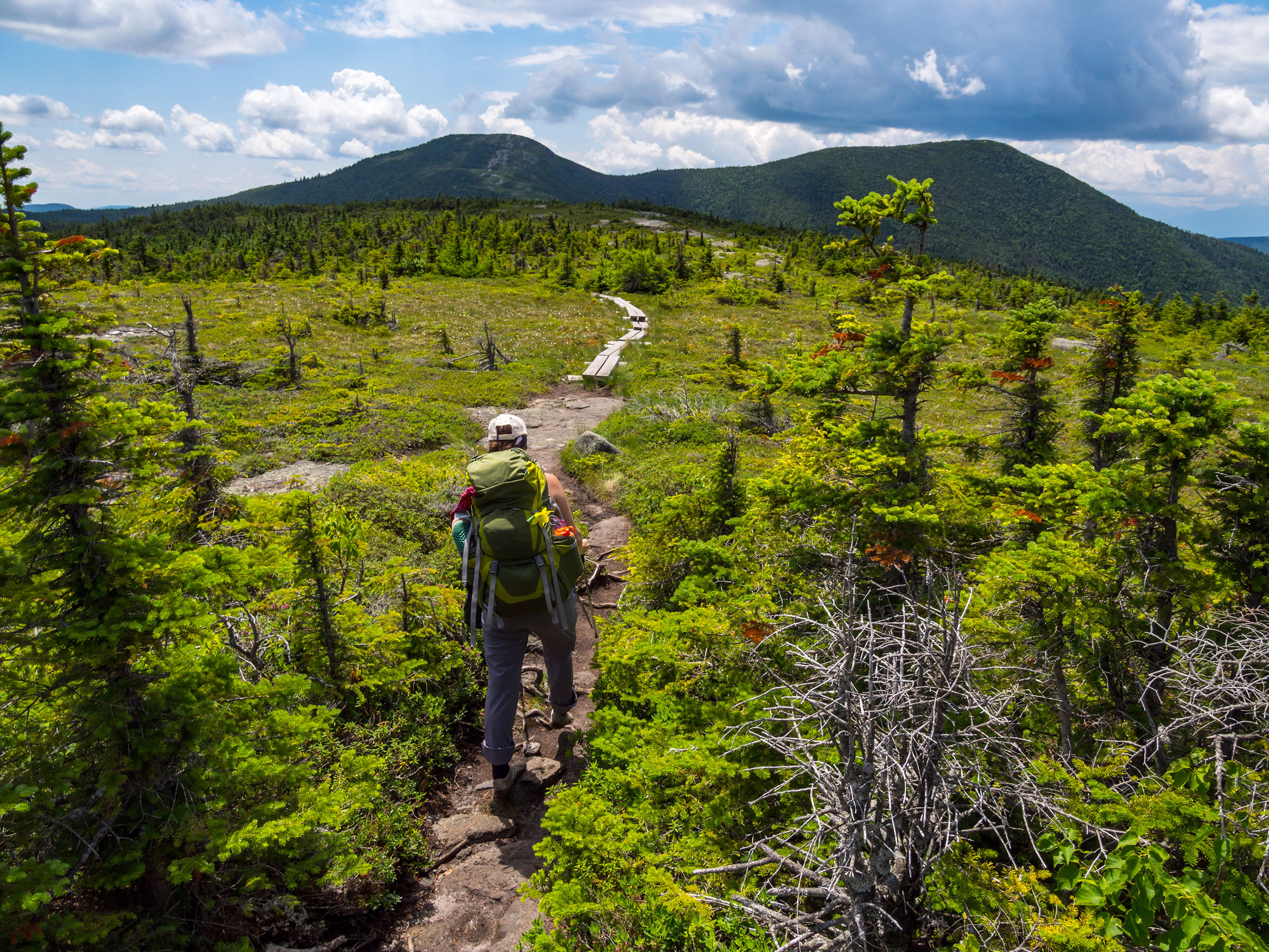
Maine’s Lakes and Mountains is filled with spectacular ways to hit the trail. Whether it is remote backcountry hiking, hoofing it up to the summit of Jockey Cap for the views, or just a leisurely walk in the woods, we’ve got a trail for you. Seasoned hikers will easily find many of our trails, such as the Toughest Mile of the AT, to their liking. Beginners and soft adventurists will also find a good selection of trails, walks, and climbs. We’ve put together five amazing day hikes on the AT as well.
An invaluable online resource for people-powered trails is Maine Trail Finder. Search the database of four-season trails to find the right trail for your next adventure with interactive trail maps, trail descriptions, pictures, and trip reports.
Join the Second Nature Adventure Challenge—a trail challenge that encourages and rewards hikers of all abilities for exploring the region. Whether you hike one trail or all nine, the website lets you log your adventures and earn digital badges for each trail!
top trails
The Appalachian Trail
Commonly referred to as the AT, the Appalachian National Scenic Trail is a 2,190+ mile long public footpath which runs from Georgia to Maine. Maine’s 281 mile section includes what is considered the “Toughest Mile” through the Mahoosuc Notch. Read more about five day hikes on the AT in Maine’s Lakes and Mountains below.
Length: Varies
Difficulty: Easy, Moderate, Difficult
Maine Huts & Trails
Maine Huts and Trails, with headquarters in Kingfield, is a nonprofit that manages four backcountry eco-lodges and linking trails, perfect for a hut-to-hut adventure.
In winter the trails offer a backcountry experience for skiers, snowshoers, and fat bikers. When summer comes around, their trail network expands to welcome hikers, mountain bikers, and trail runners.
Length: nearly 80 miles
Difficulty: Easy and Moderate
The East Coast Greenway
The East Coast Greenway is a national system that consists of 3,000 miles of networked trails linking Calais, Maine, to Key West, Florida spanning the entire Eastern Seaboard.
Maine’s Lakes and Mountains is home to two designated portions of the system that run primarily along the Androscoggin River’s banks: Lewiston Riverside Greenway and Lisbon Trail System.
Combined Length: 4.75 Miles
Five AMAZING APPALACHIAN TRAIL DAY HIKES
While hiking the trail from end to end is a six-month commitment that few hikers attempt, it’s possible to experience Maine’s portion of the AT by doing day hikes that begin at easily accessed trailheads. Remember that hiking the AT is not a simple walk in the woods, so be prepared by bringing proper clothing, gear, and supplies. But, if you’re tempted by the idea of doing the trail in sections, check out these six-day hikes on the AT.
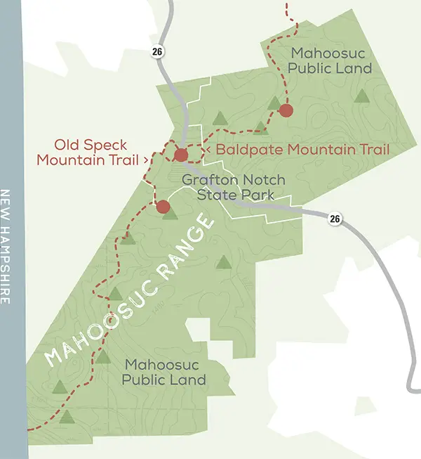
1. Old Speck Mountain: Grafton Notch
The summit of 4,170-foot Old Speck Mountain is reached by a spectacular 3.8-mile hike up the AT from a trailhead in the Grafton Notch. The section traverses the range crest, dipping through an obstacle course of boulders in narrow Mahoosuc Notch, the toughest section of the entire trail, up steep, wooded slopes to a high ridge which leads south to the rocky top of Old Speck. This iconic AT hike ends at a summit tower that offers 360-degree views across the Mahoosuc Range and the distant White Mountains. Descend back down the AT for a 7.6-mile round-trip hike. Grafton Notch also offers plenty of scenic sights, including Screw Auger Falls, Moose Cave Gorge, and Mother Walker Falls.
2. Baldpate Mountain and Table Rock: Grafton Notch
Heading northeast take the trail for 3.8 miles to the skyscraping summit of 3,790-foot Baldpate Mountain’s East Peak. This AT section, nicknamed the “Stairway to Heaven” and the “Menacing Mile,” includes a mile-long stretch of steep calf-burning trail to West Peak’s summit, but the reward is an expansive view without a town or road anywhere in sight. During the first two miles, you’ll cross a marsh on a boardwalk and then climb the white-blazed trail to Baldpate Lean-to, a sheltered campsite. Past the lean-to, the Menacing Mile scrambles over boulders and granite slabs with metal rungs to the top of West Peak. Turn around here for a 5.8-mile round-trip hike, or continue another mile to East Peak’s higher summit.
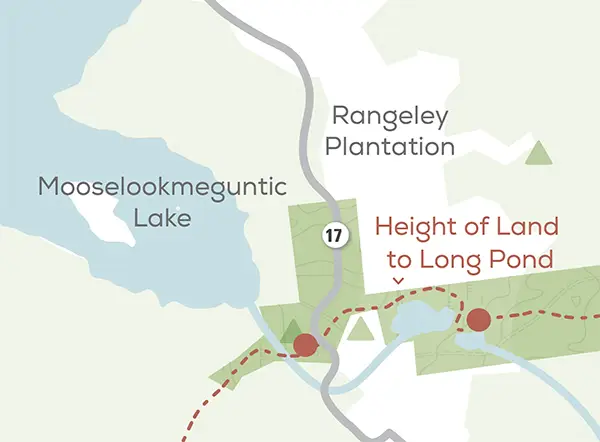
3. Height of Land to Long Pond: Rangeley Lakes Region
This easy 6-mile round-trip hike on the AT begins near the famed Height of Land Overlook and heads east over rounded Spruce Mountain to a sandy beach on the east side of Long Pond. Access the trail off Rt. 17 as it threads through tall hardwood trees, with soft sunlight dappling ferns and mosses on the forest floor, and passes Moxie Pond after a mile and a half. Continue on the AT past Long Pond, a broad lake with summer cabins dotting its shoreline, to the beach. After a refreshing swim in Long Pond or nearby Sabbath Day Pond, retrace your steps back to Route 17.
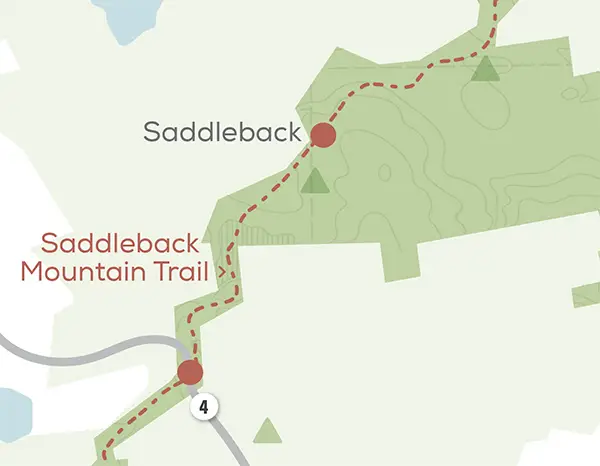
4. Saddleback Mountain: Rangeley Lakes Region
The Appalachian Trail climbs 5.7 miles to the top of Saddleback Mountain, the 8th highest peak in Maine, east of Rangeley. The easy-to-follow trail, beginning at the AT Piazza Rock Trailhead on Route 4, passes ponds and lush woods to scenic vistas across Rangeley Lake from the airy summit. The out-and-back trek up Saddleback is the full deal with 2,250 feet of elevation gain and 11.4 miles of hiking round-trip. The first four miles offer easy walking through verdant woods and only one steep section. Past Eddy Pond, the trail becomes steep and follows Saddleback’s south ridge above treeline. This open trail yields dramatic views across western Maine before reaching the mountain’s 4,120-foot granite summit. Energetic hikers often continue another 1.6 miles to The Horn, Saddleback’s north twin.
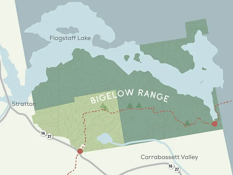
5. Bigelow Mountain Section: Flagstaff Lake Area
The 16.3-mile Bigelow Mountain segment of the Appalachian Trail is one of Maine’s great hikes, traversing the high crest of the range and passing over six major peaks, including 4,145-foot West Peak, the range high point. The best day hike begins at the Stratton Pond Trailhead off Route 16/27 and climbs Bigelow’s south flank to the range crest. After 5.9 miles, the AT tops The Horns, a 3,805-foot peak with twin-summits. Turn around here and return to the trailhead for an 11.8-mile round-trip hike.
For a shorter hike, start at the East Flagstaff Trailhead on the east side of the Bigelows. Follow the AT west up Little Bigelow Mountain for 3.2 miles, passing reflecting pools and rocky ledges with views across Flagstaff Lake.
even More hiking Trails
Bethel Area
Long Mountain, Route 35, Bethel
Length: 4.4 miles, Round Trip | Surface: Dirt/Forest Floor, Rock/Ledge, Boardwalk/Bog bridging | Difficulty: Moderate
McCoy Chapman Forest North Rd., Bethel
Length: 5.6 miles, Network | Surface: Dirt/Forest Floor, Rock/Ledge, Grass | Difficulty: Moderate
Moose Cave Gorge, Grafton Notch State Park, Grafton Twp
Length: 0.4 Mile Loop | Surface: Dirt/Forest Floor, Gravel/Crushed Stone, Rock/Ledge | Difficulty: easy
Round Mountain, Hunts Corner Rd., Bethel/Newry
Length: 1.9 miles, Round Trip | Surface: Dirt/Forest Floor, Rock/ledge, Grass | Difficulty: Moderate
Summit Ridge Trail, Locke Mountain Rd., Bethel/Newry
Length: 5.1 miles, Network | Surface: Dirt/Forest Floor, Rock/ledge, Grass | Difficulty: Moderate
Greater Bridgton
Holt Pond, Route 302, Bridgton/Naples
Length: 5.3 Miles, Network | Surface:Dirt/Forest Floor | Difficulty: easy
Jockey Cap, Off Route 302, Fryeburg
Length:0.8 Miles, Round Trip | Surface: Dirt/Forest Floor, Rock/Ledge, Grass | Difficulty: Moderate
Pondicherry Park, Off Route 302, Bridgton
Length: 2.3 Miles, Network | Surface: Dirt/Forest Floor, Wood Chips | Difficulty: Moderate
Lewiston-Auburn
Mount Apatite Park, Stevens Mills Rd., Auburn
Length: 7.6 Miles, Network | Surface: Dirt/ Forest Floor | Difficulty: Easy, Moderate
Thorncrag Nature Sanctuary, Highland Spring Rd., Lewiston
Length: 7.6 miles, Network | Surface: Dirt/Forest Floor | Difficulty: Moderate
Maine’s High Peaks
Bigelow Preserve, Fire Wardens and Horn Pond Trails Loop, Dead River and Wyman Township
Length: 12.4 miles, loop | Surface: Dirt/Forest Floor, Rock/Ledge | Difficulty: Difficult
Cathedral Pines Pathways, Off Route 27, Eustis
Length: 2.0 miles, Network | Surface: Dirt/Forest Floor, Groomed Snow | Difficulty: Easy
Daggett Rock, Wheeler Hill Rd., Phillips
Length: 0.6 Miles, Round Trip | Surface: Dirt/Forest Floor, Rock/Ledge | Difficulty: Easy, Moderate
Crocker Cirque – AT, Route 27, Carrabassett Valley
Length: 16 miles, Round Trip | Surface: Dirt/Forest Floor, Gravel/Crushed Stone, Rock/Ledge | Difficulty: Difficult+
Narrow Gauge Pathway, off Route 27, Carrabassett Valley
Length: 6.6 Miles, one way | Surface: Crushed Stone, Groomed Snow | Difficulty: Easy
Sugarloaf Mountain – AT, Caribou Valley Rd., Carrabassett Valley
Length: 5.3 Miles, Round Trip | Surface: Dirt/Forest Floor, Gravel/Crushed Stone, Rock/Ledge | Difficulty: Difficult
Oxford Hills
Mount Tire’m, Off Route 37, Waterford
Length: 1.2 Miles, Round Trip | Surface: Dirt/ Forest Floor, Rock/Ledge | Difficulty: Moderate, Difficult
Roberts Farm Preserve, Roberts Rd., Norway
Length:7.5 Miles, Network | Surface: Gravel/Crushed Stone, Groomed Snow, Dirt/Forest Floor, Grass | Difficulty: Easy, Moderate, Difficult
Streaked Mountain, Buckfield, Hebron, Paris
Length: 1.2 miles, Round Trip | Surface: Dirt/Forest Floor, Rock/Ledge | Difficulty: Moderate, Difficult
Packard Trail, Sodom Rd., Buckfield
Length: 2.3 miles, Network | Surface: Dirt/Forest Floor, Grass | Difficulty: Moderate
Rangeley Lakes
Bald Mountain Trail, Bald Mountain Rd., Oquossoc
Length: 2.3 Miles, Network | Surface: Dirt/Forest Floor, Rock/Ledge | Difficulty: moderate
Hatchery Brook Preserve, Manor Rd., Rangeley
Length: 1 mile, loop | Surface: Dirt/Forest Floor | Difficulty: Easy
Mingo Spring Trail & Bird Walk, Mingo Loop Rd., Rangeley
Length: 3.4 miles | Surface: Dirt/Forest Floor | Difficulty: Easy, Moderate
Piazza Rock – AT, Off Route 4, Sandy River Pit., Rangeley
Length: 4.1 Miles, Round Trip | Surface: Dirt/Forest Floor, Rock Ledge | Difficulty: Moderate, Difficult
Rangeley Lakes Trail Center, 524 Saddleback Mountain Rd., Rangeley
Length: 25 miles, Network | Surface: Dirt/Forest Floor, Gravel/Crushed Stone, Groomed Snow | Difficulty: Easy, Moderate, Difficult
Saddleback Mountain – AT, Off Route 4, Sandy River pitt., Rangeley
Length:11.4 Miles, Round Trip | Surface: Dirt/Forest Floor, Rock Ledge | Difficulty: Difficult+
River Valley
Flint Woods and Village Woods, Anson St./Titcomb Hill Rd., Farmington
Length: 1.8 Miles, Network | Surface: Dirt/ Forest Floor, Gravel/Crushed Stone, Grass, Sand | Difficulty: easy
Kineowatha Park, High St., Wilton
Length: 1.8 miles, Network | Surface: Dirt/Forest Floor, Gravel/Crushed Stone, Grass, Sand | Difficulty: easy
Rumford Whitecap Mountain Preserve, East Andover Rd., Rumford
Length:4.6 miles, Network | Surface: Dirt/Forest Floor, Rock Ledge | Difficulty: Moderate
Swift River Walking Trail, Intersection of Route 2/Route 120, Rumford
Length: 0.5, One Way | Surface: Pavement | Difficulty: Easy
Foundry Trail, Foundry Rd., Livermore Falls
Length:0.7 Miles, one way | Surface: Pavement | Difficulty: Easy
French Falls River Walk, French Falls Dr., Jay
Length: 1.2 miles, Network | Surface: Dirt/Forest Floor, Rock/Ledge, Wood Chips, Grass | Difficulty: Easy
The Whistle Stop Rail Trail, Farmington, Jay, Wilton
Length: 14.0 Miles, One Way | Surface: Gravel/Crushed Stone, Sand | Difficulty: Easy
Sebago Lakes
Bald Pate Mountain Trail, Off Route 107, Bridgton/Sebago
Length: 6.7 miles, Network | Surface: Dirt/Forest Floor, Gravel/Crushed Stone, Rock/Ledge, Grass, Groomed Snow | Difficulty: Easy, Moderate
Donnabeth Lipman Park, Chaffin Pond Preserve Rd., Windham
Length: 15 miles, Loop | Surface: Dirt/Forest Floor, Groomed Snow | Difficulty: Easy, Moderate
Douglas Mountain, Off Route 107, Sebago
Length: 2.8 Miles, Network | Surface: Dirt/ Forest Floor | Difficulty: Moderate, Difficult
Mayberry Hill Preserve, 385 Mayberry Hill Rd., Casco
Length: 1 mile, Loop | Surface: Dirt/Forest Floor | Difficulty: Easy
Ways to Adventure
On the trail
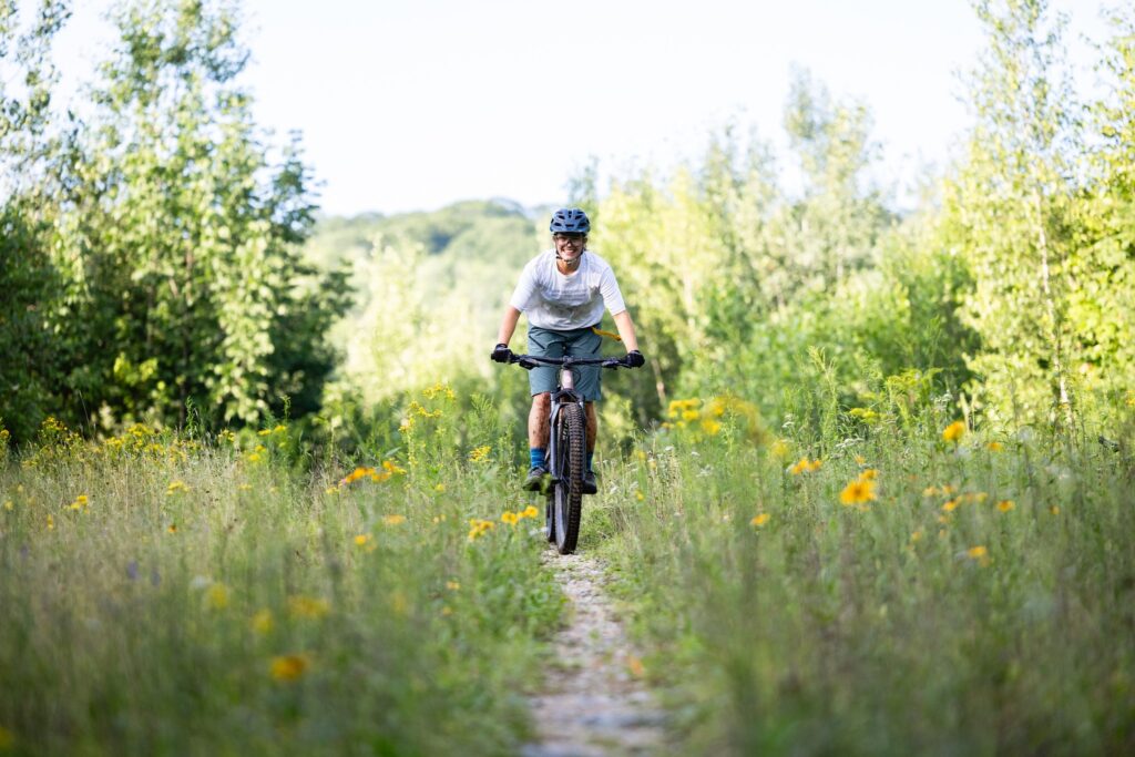
hiking
Maine’s Lakes and Mountains is filled with spectacular ways to hit the trail. Whether it is remote backcountry hiking, hoofing it up to the summit of Jockey Cap for the views, or just a leisurely walk in the woods, we’ve got a trail for you.
On the trail
Mountain Biking
Though you do not have to be in the mountains to enjoy this sport, the Maine’s Lakes and Mountains region offers the perfect setup for bikers looking for the challenge of single-track.
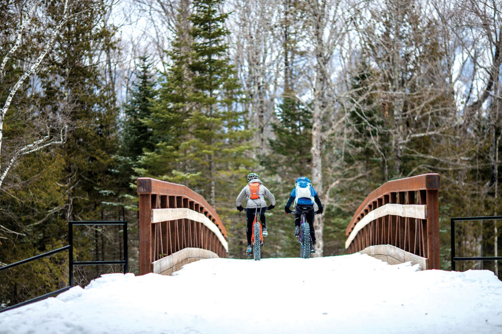
On the trail
fat Biking
If you love mountain biking and winter, fat biking might be your new favorite sport. Fat bikes use huge, grippy tires that allow riders to take to trails typically used by snowmobilers and cross-country skiers.
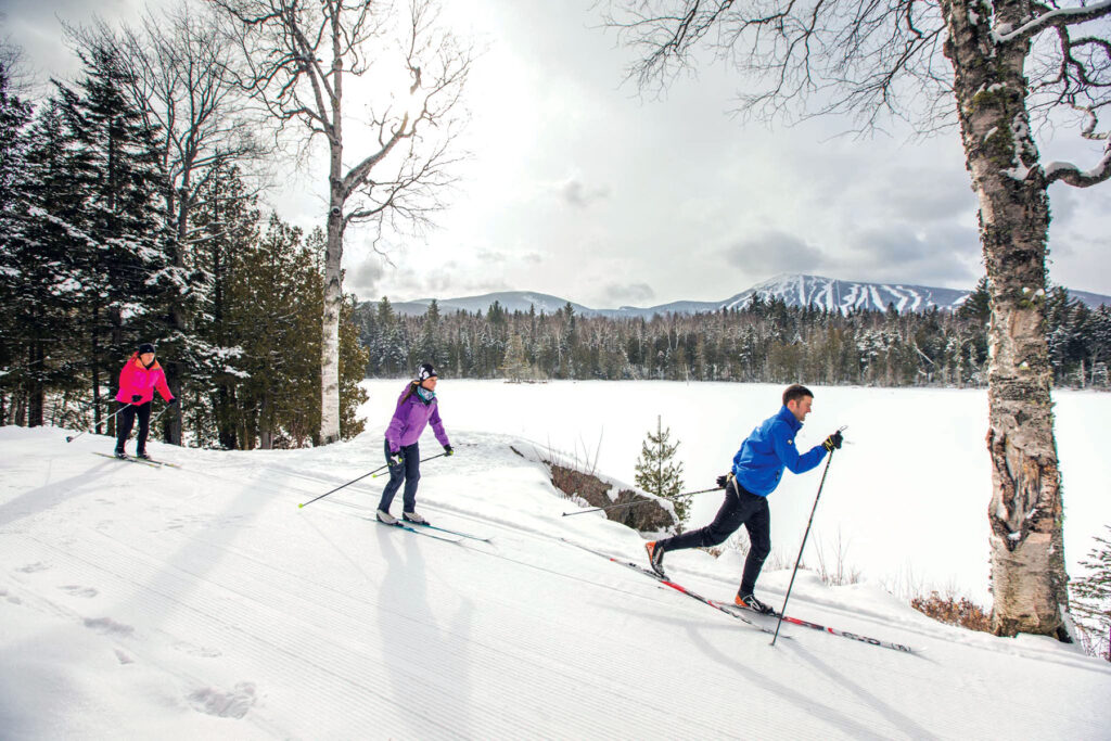
On the trail
Nordic Skiing
On a crisp, sparkling winter day, one of the best ways to take in Maine’s Lakes and Mountains snowy landscape is to venture out on cross-country skis.
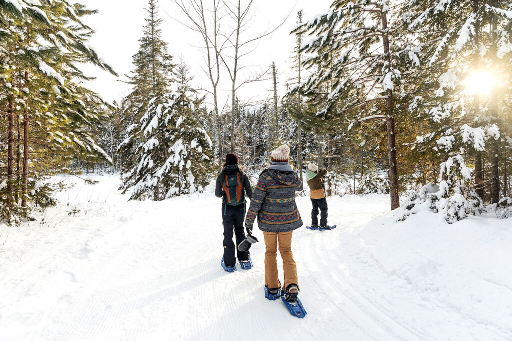
On the trail
snowshoeing
Snowshoeing enthusiasts have options lots of options here. With over 250-miles of groomed trails across the region
On the trail
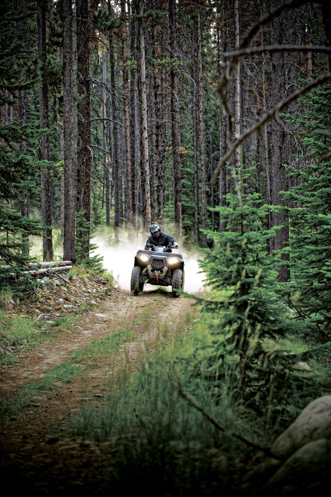
ATV Riding
Take on terrain from rocky climbs up a mountain, to smooth cruises through open plains as you explore extensive miles of ATV trails spanning mountains, forests, and meadows.
On the trail
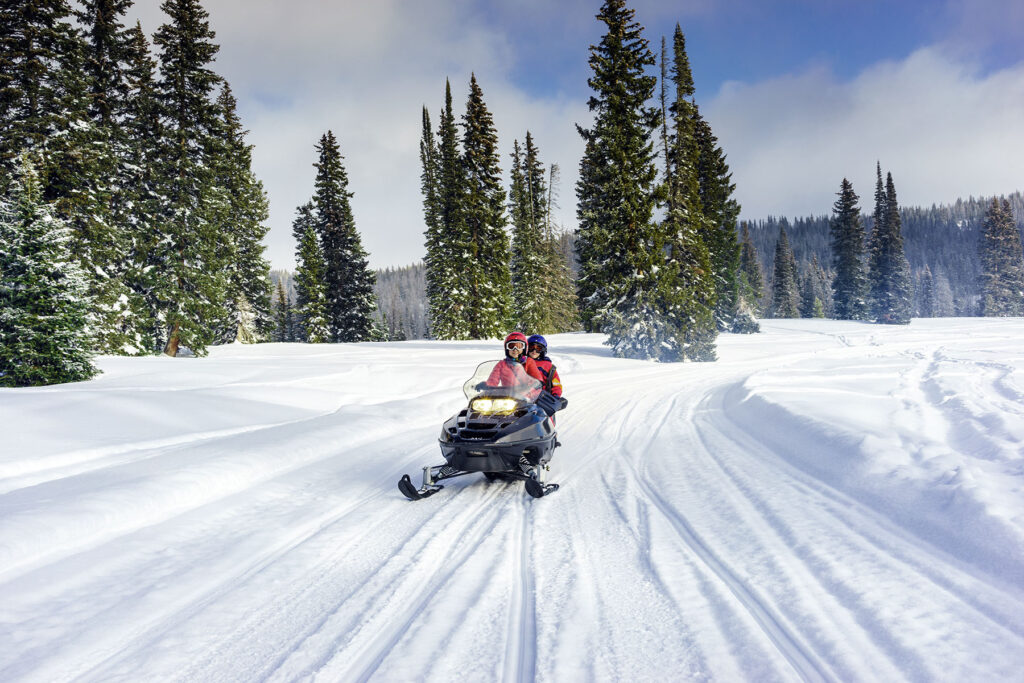
snowmobiling
With over near-endless miles of groomed trails maintained by local riding clubs, you’ll always find new places to explore amid the incredible scenery, fragrant pine forests, and wide-open plains.
Nature and Wildlife
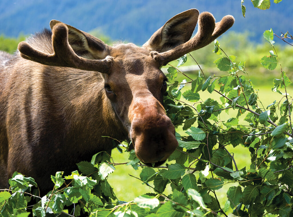
Moose Spotting
You can spot moose throughout most of Maine, but their population is most significant in more secluded areas, including much of Maine’s Lakes and Mountains.

Nature and Wildlife
birding
The forests, fields, and wetlands of Maine’s Lakes and Mountains are the ideal setting to experience the thrill of birdwatching. Many highly coveted species can be found in the area’s boreal forests, including woodpeckers and Bicknell’s Thrush.
Plan Your Trip
Maine’s Lakes and Mountains offers a variety of resources to help you plan your next visit, including an annual visitor’s guide, stand alone map, and the new Adventure Guide App.
Visitor's Guide
Our Free Visitor's Guide will help inspire your next adventure along our mountain trails, lakes, scenic byways, bustling towns and more.
Map of the Region
Companion to the Visitor Guide, our dual-sided planning map will help you find your way to adventure in every season throughout the region.
Adventure Guide App
The App will point the way to all kinds of adventures, experiences and destinations in Maine’s Lakes and Mountains with GPS location maps and alerts.
Adventure Respectfully
Our lakes, mountains, and forests are worthy of respect. Whether you’re venturing out into our vast public or private lands or parks, here’s what you can do to conserve the area’s natural resources for all.
other resources
Take Care of the Land
Tread lightly and leave no trace. Keep this place as pristine as you found it.
Where ya headed?
Check if you’ll be on public or private land and if there are any restrictions or fees. Always research your destination ahead of time.
Stick to established trails & roads.
Whether hiking, biking, angling, or ATVing, always stay on a designated trail.
DON’T DAMAGE TREES
To protect the forest, only build fires in approved sites, don’t leave them unattended, and extinguish them thoroughly.
Avoid spreading invasive species.
Don’t transport firewood, brush your boots, and wash and dry your boat before heading to your next adventure.
Avoid peak hours
Plan around peak hours midday to avoid crowds. Have a Plan B in case the parking lot is already full.
No litterbugs allowed
If you pack it in, pack it out, including food waste like apple cores. Bring bags for pet waste.
When nature calls
If you have to go, pick a spot at least 100′ off the trail or away from a body of water, and bury your poop 6″ deep.